- Home
- Up to XII Students
- Decide Stream For XI & XII
- Career Options
- Entrance Preparation
- Sample Papers
- Entrance Exams after 12th
- International Entrance Exams To Study Abroad
- Foreign University Comparison
- Apply to Foreign Universities
- General Preparation For Students Going To Study Abroad
- Write A Report
- Write an Article
- Write An Essay
- Important Dates
- UG & PG
- Tech Tips
- Mock Test
- GROOMING
- HOBBIES
- K PLUS
- Working Professional
- OTHERS
The E-Cadastre technology to the service of the society of information
Dr.R.Udayakumar
Prof & Dean ,Department of computer science & Information Technology,
Kalinga University, Raipur, Chhattisgarh-India r.udayakumar@kalingauniversity.ac.in,rsukumar2007@gmail.com
Abstract
In this work the Web application “E-Cadastre” is presented. E-Cadastre has been created in order to provide access to Cadastral data through the Internet. Functions and characteristics of this application and details about the programming tools used for its creation are presented. Great importance was placed in the design of a visual query interface so that the retrieval of data from users without essential experience in Geographic Information Systems or in database management systems can be possible even by using complex search criteria. In this work there is also a detailed presentation for the application’s user interface. Also, several changes in Cadastral specifications are proposed in order to contain metadata for the cadastral survey data. Advantages from the function of this application in Cadastral offices are presented, as well as future plans about the evolution of this application.
Introduction
One of the many functions of the Hellenic Cadastre is the provision of access to Cadastral diagrams and tables at the Cadastral Offices, which are situated at each local authority where Cadastral Survey Studies are conducted. Notaries, lawyers and other scientists that are related to the Cadastre, have also the need for direct access to the cadastral data due to professional needs. But until the Cadastral data are finalized, the access to these data (diagrams and tables) is done through the 1st and 2nd Suspension at the respective local authorities. During each Suspension, each property owner can verify the precision and correctness of the data he has declared; he can seek for indications that will help him locate his property; or he can submit an objection if he disagrees with the data that concern his property.
In this work an application is presented that has been created in order to provide access to Cadastral data of a local authority Suspension through the Internet using the Web technology. In this way, every property owner has the capability to access the Cadastral survey data from any place on earth.
This application has been created in such a way that it handles the spatial and descriptive data exactly as they are delivered by the surveyors, according to the specification (version 5.0) that has been established by Ktimatologio S.A. Ktimatologio S.A is the company responsible for the Hellenic Cadastral survey studies.
Key function of this application is the provision of all the necessary information to the owner about his property through a modern user interface. Depending on his profession, each user type of user has access at a different level of information so that sensitive personal data are protected.
Great importance was placed in the design of a visual query interface so that the retrieval of data from users without essential experience in Geographic Information Systems or in database management systems, can be possible even by using complex search criteria.
Details about the technologies used for the creation of this web-based application are also presented.
Several changes in Cadastral specifications are proposed in order to contain metadata for the cadastral survey data. With the addition of metadata, users can have information about the quality of cadastral data.
In this work there is also a detailed presentation for the application’s user interface.
1. Functions and characteristics of the WEB-based application presented
To determine the characteristics of an application, one must first verify who uses this application and what kind of services can a traditional cadastral office offer. The users of this application are:
Property owners,
- Personnel in Cadastral Offices,
· Personnel in local Authority where Cadastral Survey Studies are conducted
During each Suspension each property owner can
· verify the precision and correctness of the data he has declared; he can seek for indications that will help him locate his property; he can submit an objection if he disagrees with the data that concern his property; acquire cadastral extracts with the data that he has declared.
Some of the functions and characteristics of this application are
- Provide all the necessary information to the owner about his property through the World Wide Web, as well as cadastral extracts with the data that he has declared.
- The user interface of the application is modern, functional and it does not require from the user any kind of knowledge about the structure and the complexity of the digital cartographic and descriptive data of Cadastre
- The users of this application are able to retrieve data with complex searching criteria such as combining cartographic and descriptive data, without requiring any particular knowledge of computer operation.
- Easy export of statistical data about the local authority, i.e. total number of declarations, number of Persons depending on the place of residence, number of buildings per use, number of rights per type of possession of property etc.
- Each user depending on his profession (lawyer, land registrar, other professionals, plain citizen) has access at a different level of information so that sensitive personal data are protected.
2.Technical details of the application
2.1 Programming tools used
For the creation of this application the following programming tools are used:
- Microsoft® FrontPage® 2000 and Macromedia® Dreamweaver® MX for the creation of web pages
- Programming languages: VbScript in Active Server Pages and JavaScript in dynamic HTML pages
- Microsoft® IIS® v.5 in order to run this Web application on the Internet
- ESRI® ArcIMS® 4 ActiveX Connector offers the opportunity to add maps to existing ASP applications.
- Microsoft® Access® 2000 as the database tool for managing the cadastral descriptive data
- Cadastral extracts are provided in PDF format documents readable by Adobe® Acrobat Reader®
The operating system where all these programming tools used is Microsoft® Windows® 2000 Professional. This operating system is used as a server for the application.
2.2 How the application works
From the user’s perspective, a button inside the application is clicked, an operation is performed, and a result appears on the screen. This summarizes a complex process of communication between the user who interacts with this application and the server.
What actually occurs when the user performs an action is that a request is sent from the user’s web browser through the Internet to the Web server (in our case the Internet Information Server, the program responsible for running this application).
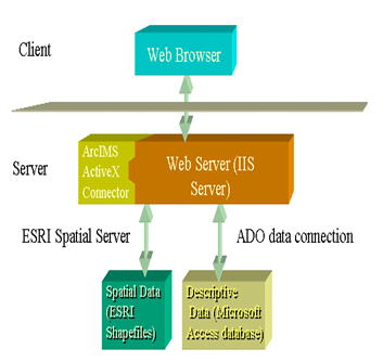
Figure 1. How the application works
Depending on the request, the IIS server interacts with ESRI ArcIMS ActiveX connector to access the spatial data and/or the descriptive data. After processing, the Web server returns the response to the viewer.
3. Users and user rights
As stated in previously, the of users this application are:
- Property owners: Everyone who has declared a property
- Personnel in Cadastral Offices
- Personnel in local Authority where Cadastral Survey Studies are conducted
The rights of each type of user are the same ones the user would have as a citizen served in a traditional cadastral office. The rights of each user are summarized in the following table:
Table 1. Users and user rights
For security reasons, every user is provided with a unique username and password. When a user wants to use the application, he must enter this username and password when asked. The steps that one should follow in order to access the cadastral data in this application are:
- Each user fills a request form with his personal data inside the application
- The application checks the integrity of the data the user just entered.
- If the user who has requested access is valid, then the application provides him via e-mail with a username and a password to get access to the data.
The method suggested is similar to the Greek “TAXIS” system for tax payment, where every citizen can have access to it via the Internet
4.The user interface of the application
One of the most important steps in the creation of an application is the design of its user interface. The reality is that a good user interface allows people to work with the application without having to read the manuals or receive training (Constantine 1995).
Some general characteristics of the application’s user interface are
- Consistency of the user interface. Colors, buttons, labels with same characteristics are used consistently throughout the application
- The user is driven to the desired information just by clicking and choosing step by step
- There are tool tips in links or buttons
- All links act like hover buttons
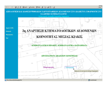
Figure 2. The startup screen of the application
The traditional cadastral table is a non-friendly book with dimensions 840 x 300 cm open. There are two of these books. One with its data with cadastral number in ascending order and one with owner’s name in ascending order. Instead of it, the cadastral table inside this application is a dynamic table. Its contents depend on the search criteria the user entered.
· There is a tool tip in every record of the table to inform the user about the cadastral number.
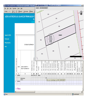
Figure 2. Overview of dynamic cadastral table and dynamic cadastral diagram.
As the user clicks on a record of the table, a diagram of the parcel with this number appears on a window. The diagram appears in raster format and the user is not allowed to save it in his local disc by right clicking on the image. The diagram is dynamic. If the user clicks on another parcel, the diagram will focus on that parcel. The diagram of every parcel has a graphical scale and a north arrow.
4.1 Designing the visual query interface
Before the interface was designed, previous evaluations of query languages and interfaces were surveyed to high-light any key areas that needed to be addressed. Problems most common Identified in query interfaces are:
- Increasing complexity when specifying the order of Boolean operators with parentheses as the query grows.
- Differences in meaning between the Greek (or English) and Boolean logic meaning behind the and and or operations. For example, in English the user may pose the query:
“Find me all the pet owners that have cats and those that have dogs as pets.”
If this query were translated directly from English into a query language such as SQL, the constraint clause would take the form:
where pet = “cat” and pet = “dog”
The results of this query would always be an empty set as it is not possible for a pet to be a cat and a dog; the constraints of the query should have been ored together.
4.2 Solutions for the Query interface
There are four solutions concerning the problems stated above. The first solution has to do with the use of Greek language for defining operations between the conditions entered in query. The user chooses the condition in his language in the application’s query interface and enters the desired constraint value. The application displays the constraint and the condition in Greek language.
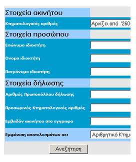
Figure 4. Intuitive understanding of the “AND” operant in the query design
The second solution has to do with the intuitive understanding of the “AND” operant in the query design by the naive user when the query fields are positioned (Fig.4).
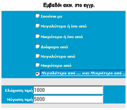
Figure 5. Choosing query conditions in Greek
language and cover of complex search criteria.
The third solution has to do with frequently used complex search criteria such as “declared area must be greater than 1000 sq.m and less than 5000 sq.m” (Fig.5). In this example, the user selects this condition and enters two values: The value of 1000 and the value of 5000.
Use of
wizards is the fourth solution used.
A wizard presents a series of steps for a user to complete. A wizard includes one or more forms that contain a variety of fields for getting information from the user. After the user has completed the steps in the wizard, the wizard creates an SQL complex query based on the information provided by the user and displays the data retrieved when the query is executed.
5. Additions proposed to the Cadastral
data
5.1 Additions to the data of the Cadastral Table
The experience from the suspensions in cadastral survey studies showed that the addition of more information to the cadastral table is necessary concerning the parcels. These additions are:
The coding of the parcels prior to the cadastral survey. This addition is important because owners and legal documents refer to parcels using this coding.
The maximum error in sq.m for the area of each parcel calculated from the accuracy of the cadastral data. About 50% of the objection submitted concerns the area reported by the cadastral study. This number is important on the outcome of the owner’s objection about the area of his/her parcel (if it will be accepted or not)
5.2 Additions of metadata to the Cadastral specifications
Additions of
metadata to the Cadastral specifications must be done in order to contain metadata
for the cadastral survey data. These metadata are necessary for determining the
quality of the cartographic data
Metadata for the previous cartographic background like the name of the map, year of construction, agency that constructed the map, scale of the map, Cartographic projection of the map, etc.
Metadata for the
methods used for the production of the cadastral cartographic data such as
accuracy results of cartographic transformations; accuracy results of the earth
measurements (if any) etc.
6. Future plans
Some of the future plans concerning the evolution of this application are
- Inclusion of other types of users besides the ones described in the previous, such as surveyors, engineers, lawyers, notaries etc.
- Availability of digital cartographic cadastral data via the Internet. Surveyors, Civil Engineers and other scientists can have access to these data by paying an amount of money.
- Service of the citizens after cadastral data are
finalized.
- Availability of all metadata information described in the previous with an estimation of the accuracy of cartographic data for the scientists who are interested in this kind of information.
- Availability of the content of the application
in English and Greek language.
7. Advantages of the present application
There are plenty of advantages from the use of this application during the 1st or 2nd suspension of cadastral diagrams and tables comparing to traditional cadastral offices such as:
Lower cost: Property owners will be served from this ”E-Cadastral office” and as a result fewer personnel is needed. Additionally, every property owner who has access to the internet, can download and print his cadastral extract instead of receiving it via snail mail as it happens today.
Less Bureaucracy in Cadastral Offices: Objections about typical errors (for example erroneous last name of owner in cadastral tables) do not need to be conducted in paper because they will be recorded directly into the database. Cadastral extracts will be only in electronic format and not in paper.
Better and faster service to the citizens: Owners using the query interface of the application can have instant access to the data of their property without searching in hundreds or maybe thousands of papers in traditional cadastral offices.
Greek citizens worldwide can have access to the data of Suspension and see all the necessary information about their property.
8. References
Ambler, W. (1998). “Building Object Applications That Work: Your Step-By-Step Handbook for Developing Robust Systems with Object Technology”. New York: Cambridge University Press.
De Gunst M, Van Oosterom P. (1997). “Network computers at the Dutch Cadastre”,46th Photogrammatric week Stuttgart 1997 – University of Stuttgart – Institute of Photogrammetry
Hearst M., 1999, “User Interfaces and Visualization” inside “Modern Information Retrieval”, Addison Wesley Longman Publishing Co. Inc., 1999
Murray N.,Goble C., Paton N., 1998 “A Framework for Describing Visual Interfaces to Databases” Journal of Visual Languages and Computing ,Vol 9, No 4, 429-456, 1998.
Murray N., Paton N.,Goble C., Bryce J., 2000 “Kaleidoquery: A Flow-based Visual Language and its Evaluation” Journal of Visual Languages and Computing, Vol 11, No 2, pp.151-189
Nyerges T., Mark D., Laurini R., Egenhofer
M., 1995 “Cognitive Aspects of Human-Computer Interaction for Geographic
Information Systems” Kluwer Academic Publishers 1995
Sarafidis D. 2003 “Valuation of digital cartographic data in GIS’s. Application in Hellenic Cadastre”, Doctoral Thesis (in preparation)
Sarafidis D.,Paraschakis I., Maniatis I., 2002 “A system for managing cadastral data to the service of the society of information”, Proceedings of the HellasGIS-AUTH Congress,Thessaloniki, Greeece.
Shneiderman
B., 1998 “Designing the User Interface” Addison-Wesley Publishing Company
Shneiderman,
B., 1994 “Dynamic Queries for Visual
Information Seeking” IEEE Software,
vol. 11, #6 (Nov. 1994)
9. Web links
Denmark, Infodatabase om geodata:
http://www.geodata-info.dk
France, CNIG: http://www.cnig.fr
Great Britain, Ordnance Survey, SINES:
Hellenic
Cadastre http://www.ktimatologio.gr/
MEGRIN, GDDD: http://www.ign.fr/megrin/gddd/gddd.html
Portugal, SNIG: http://snig.cnig.pt
Sweden, GIR: http://www.ssc.se/gir
The Netherlands, Idefix: http://idefix.geodan.nl
ESRI, ArcIMS: http://maps.esri.com/
Intergraph: GeoMedia:
http://www.intergraph.com/iss/geomedia/webmap
Autodesk: MapGuide: http://www.mapguide.com/
MapInfo: ProServer: http://www.mapinfo.com/
Bentley: ModelServer: http://www.bentley.com/
Softsource: SVF plug-in: http://www.softsource.com/
PGS,
Geoshop/Lava: http://www.pgs.nl/
–

Kalinga Plus is an initiative by Kalinga University, Raipur. The main objective of this to disseminate knowledge and guide students & working professionals.
This platform will guide pre – post university level students.
Pre University Level – IX –XII grade students when they decide streams and choose their career
Post University level – when A student joins corporate & needs to handle the workplace challenges effectively.
We are hopeful that you will find lot of knowledgeable & interesting information here.
Happy surfing!!
- →
-
Free Counseling!